07 'A WICKED PROBLEM': POST-WILDFIRE RESTRUCTURING IN EXURBAN SAN DIEGO
MAY 2020


A research project developed and completed by Kate Galbo, Ri Le, and myself in the Spring 2020 course Advanced Spatial Analysis at Columbia University GSAPP.
This study investigates 2007’s San Diego County Firestorm, one of the most destructive wildfire seasons in San Diego history, with damages totaling over $1 billion (Information Insurance Institute, n.d.). The 2007 Firestorm comprised a series of wildfires that began igniting across Southern California on October 20th. A half million San Diego County residents were evacuated from their homes, an evacuation similar in scale to that of Hurricane Katrina (SANDAG, 2008). The Witch Creek Fire, which merged with another fire, the Poomacha Fire, was the largest in San Diego County.
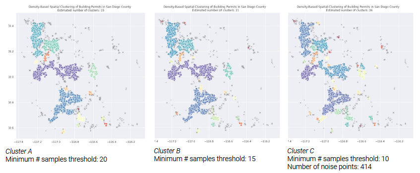
We investigated developmental patterns and growth through spatial clustering of building permits using density-based spatial clustering of applications with noise (DBSCAN) to analyze trends in permit distribution. We identified growth in the WUI zone using a classification methodology operationalized by SILVIS Lab (Spatial Analysis For Conservation and Sustainability) at University of Wisconsin, which uses land cover data to classify two different development patterns. And we explored the social context and patterns of San Diego County through non-spatial clustering on the Centers for Disease Control’s social vulnerability index (SVI) using HDBSCAN (hierarchical DBSCAN) to analyze change in percentiles. Finally, we observed spatial patterns by collocating these results. Our research suggests that the structural changes after the fire may reflect existing long-term development patterns and sociodemographic change. ︎ Full paper here.
We investigated developmental patterns and growth through spatial clustering of building permits using density-based spatial clustering of applications with noise (DBSCAN) to analyze trends in permit distribution. We identified growth in the WUI zone using a classification methodology operationalized by SILVIS Lab (Spatial Analysis For Conservation and Sustainability) at University of Wisconsin, which uses land cover data to classify two different development patterns. And we explored the social context and patterns of San Diego County through non-spatial clustering on the Centers for Disease Control’s social vulnerability index (SVI) using HDBSCAN (hierarchical DBSCAN) to analyze change in percentiles. Finally, we observed spatial patterns by collocating these results. Our research suggests that the structural changes after the fire may reflect existing long-term development patterns and sociodemographic change. ︎ Full paper here.